Carol Mendel's
Fisherman's Wharf map

|
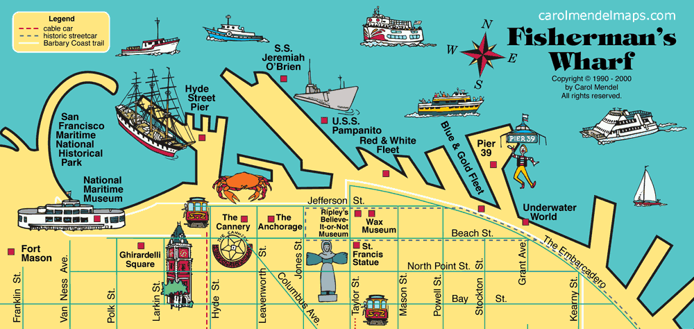
Along the waterfront just north of downtown San Francisco, Fisherman's Wharf is a center for seafood restaurants, museums, art galleries, shops, tours of the bay, and trips to Alcatraz. It is easily reached by both the Powell & Mason and the Powell & Hyde cable car lines.
Here's a list of the attractions shown on this map: |
|
|
|
| * The map shown here is from the San Francisco & the Bay Area Visitor's Map, a printed map. After that map was printed, Underwater World closed, and later reopened as the Aquarium of the Bay. | |
This map of Fisherman's Wharf is part of Carol Mendel's San Francisco Bay Area Visitor's Map, a printed map 24" wide by 18" high.
Covering one entire side of the printed map is a pictorial map showing all of the San Francisco Bay Area, featuring main roads and visitor attractions.
The Fisherman's Wharf map measures measures approximately 8" wide by 4" high, and is one of five smaller maps included on the other side. The other maps focus on Downtown San Francisco, San Jose & Santa Clara, Golden Gate Park, and the Wine Country. An index covers all the maps.
 The map costs $5, including shipping, handling, and (where applicable) sales taxes, as long as it is mailed to a U.S address.
To order a single copy of this map online, and have it mailed to a U.S. address, click on the "Buy Now" button below.
For all other orders, click here. This includes orders involving more than 1 map, laminated maps, international shipping, or payments by check or money order. Orders for 3 or more maps qualify for discounts.
Copyright © by Carol Mendel