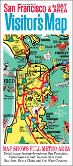
The San Francisco & the Bay Area Visitor’s Map is a full-color, pictorial map of the San Francisco Bay Area. Its six maps are printed on an 18" x 24" sheet of glossy paper, which is then folded to 4" x 9".
On one side is an 18" x 24" map of the entire San Francisco Bay Area. On the other side are five other, smaller maps, including ones of Downtown San Francisco, Fisherman's Wharf, Golden Gate Park, San Jose & Santa Clara, and the Wine Country.
Today, the map of the San Francisco Bay Area and the map of Downtown San Francisco have been updated and are available as posters and trays. For details, click or tap on one of the map names above.
Thanks to the effect of GPS and cell phones on the map business, this folded paper map is no longer updated and reprinted. However, copies of the year 2000 edition of this map are still available.
Clicking or tapping the button below takes you to PayPal, where you can order and pay using your PayPal, credit, or debit account.